Wonderful cross-country skiing experiences await on Monte Pana in Santa Cristina and in the Vallunga near Selva Gardena
Cross-country skiing in Ortisei / Alpe di Siusi:
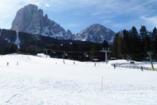
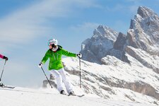
A cable car and a chairlift take you from Ortisei directly to the high plateau of the Alpe di Siusi, where an 80-kilometre network of trails awaits you. The trails run at an altitude of between 1,700 and 2,000 metres and are surrounded by impressive mountain scenery. The Alpe di Siusi is also connected to the Val Gardena Skiing Area.
Cross-country skiing in Santa Cristina:
In Santa Cristina, the cross-country skiing centre on the Monte Pana attracts visitors with its wide Palusc meadow and trails of all difficulty levels. Around 30 kilometres of trails are available for you to choose from here. The starting point is at the stadium of the cross-country skiing centre.
Car parks are available, or you can reach the centre with the Monte Pana lift or the ski bus. A challenging trail and a bus service connect the area with the Alpe di Siusi.
- Mont Dessot: easy - 2.5 km - 89 m elevation gain - blue signs
- Palusc: easy - 5.2 km - 191 m elevation gain - blue signs
- La Buja: intermediate - 6.7 km - 205 m elevation gain - red signs
- Vedl Verzon: difficult - 3.3 km - 118 m elevation gain - black signs
- Val Scura: difficult - 7.5 km - 272 m elevation gain - black signs
- Connecting trail Monte Pana-Alpe di Siusi: difficult - 8.0 km - black signs
Cross-country skiing in Selva Gardena:
Northeast of Selva Gardena, the Vallunga valley stretches into the Puez-Odle Nature Park. Here you will also find the branch of the Selva Gardena Ski and Cross-Country School. At the entrance to the valley, there are short trails that are well suited for beginners and those returning to the sport.
The longer routes lead further into the valley. This includes the 10-kilometre trail to the Pra da Rì meadow. You can park at the La Ciajota car park. From the village centre, you can reach the entrance to Vallunga on foot in about 20 minutes.
- Trail 1: easy - 1.5 km - 23 m elevation gain - green signs
- Trail 2: easy - 3.0 km - 55 m elevation gain - blue signs
- Trail 3: intermediate - 5.0 km - 81 m elevation gain - red signs
- Trail 4: difficult - 10.0 km - 210 m elevation gain - black signs